 Lýsigagnagátt
Open data
Type of resources
Available actions
Topics
INSPIRE themes
Keywords
Contact for the resource
Provided by
Years
Formats
Representation types
Update frequencies
status
Service types
Scale
Resolution
-

Boundaries of various areas within Vatnajökull National Park with special rules. 1. Esjufjöll, Jökulsárgljúfur, Skaftafell and Askja have special rules about camping restrictions, according to article 3, in regulation about Vatnajökull National Park, 300/2020. Coordinates are listed in table 2 in amendment IV in the regulation. 2. Hvannadalshnjúkur, Öræfajökull and Kverkfjöll have special limitations on, if and when motorized traffic is allowed. 3. Traditional land use areas are listed in article 26 of regulation about Vatnajökull National Park, 300/2020. Disclaimer: If there is a difference between the data and the regulation text, then the regulation text applies.
-

This data includes all defined hiking trails within Vatnajökull National Park, and selected trails near the park. The trails are drawn from hiking maps that the park has published since it was founded in 2008. The maps have been updated regularly since, last update was in 2019, (Snæfell area and a large part of the western region). These hiking maps can be viewed by selecting “Hiking map, click on frame” in the Vatnajökull National Park Mapview, (see link below).
-
Í desember 2011 var ný geóíða reiknuð fyrir Ísland í samstarfi við DTU Space í Danmörku. Megin tilgangur þessara útreikninga var að reikna nýja og nákvæmari geóíðu af Íslandi og tengja hana við Landshæðarkerfi Íslands ISH2004. Nánari upplýsingar eru á heimasíðu Landmælinga Íslands, nánar tiltekið hér: https://www.lmi.is/is/maelingar/grunnkerfi/geoida
-
Average near-East crustal velocities between summer 2015 and summer 2018. These velocities indicate velocities in the East direction. However, they could be slightly influence by velocities along the North and Up directions and are therefore called near-East. Near-East velocities were derived by decomposing the line-of-sight velocities of six Sentinel-1 interferometric time-series covering Iceland. These time-series used a single master approach and Sentinel-1 images from the following summers (mid-June to end of September): 2015, 2016, 2017, and 2018. The near-East velocity grid has a 50 m resolution.
-
Average near-Up crustal velocities between summer 2015 and summer 2018. These velocities indicate velocities in the Up direction. However, they could be slightly influence by velocities along the East and North directions and are therefore called near-Up. Near-Up velocities were derived by decomposing the line-of-sight velocities of six Sentinel-1 interferometric time-series covering Iceland. These time-series used a single master approach and Sentinel-1 images from the following summers (mid-June to end of September): 2015, 2016, 2017, and 2018. The near-Up velocity grid has a 50 m resolution.
-

Abstract is not available in english
-
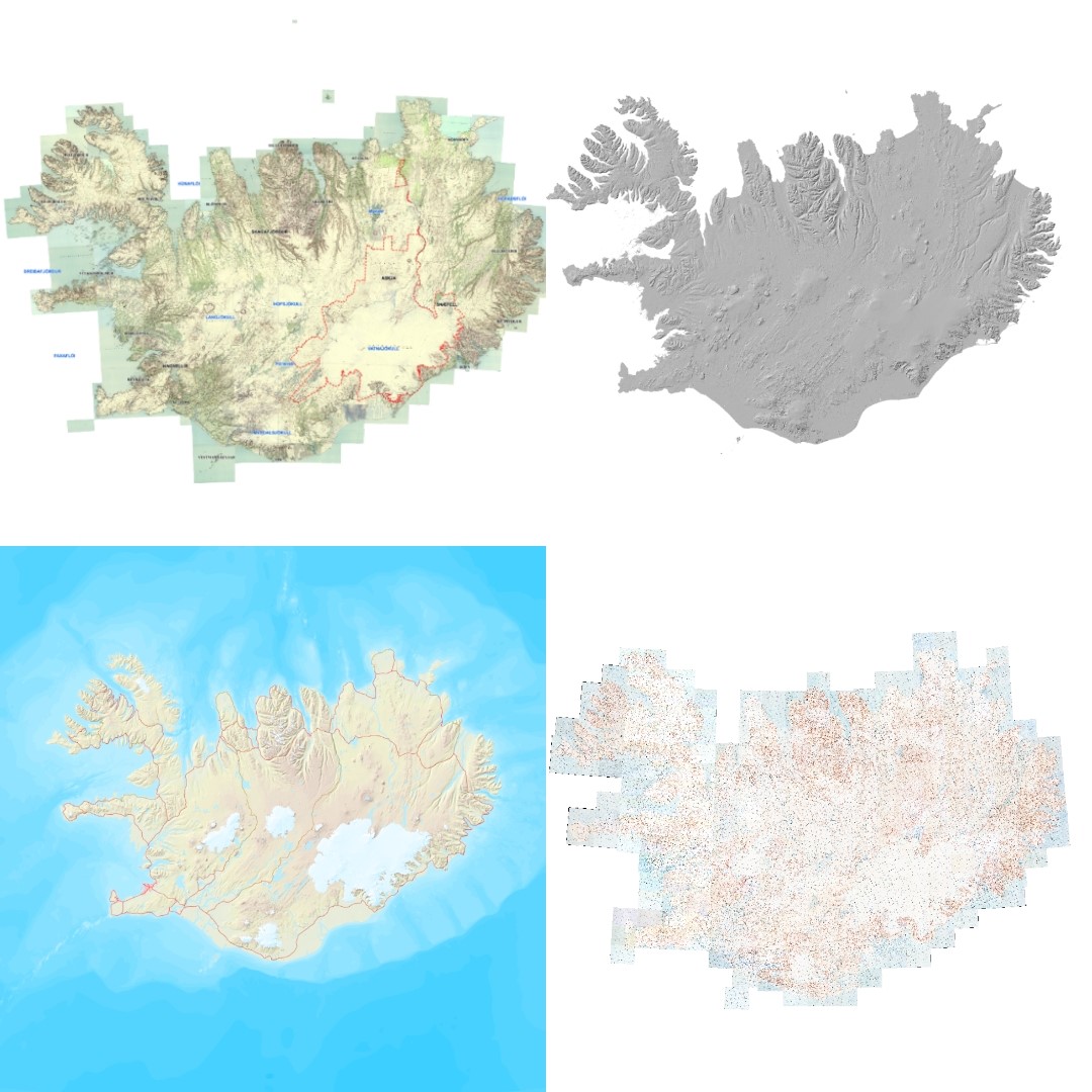
Vefþjónn fyrir landfræðileg gögn Landmælinga Íslands. Hér eru nýjustu útgáfur gagna Landmælinga Íslands aðgengilegar. Vefþjónnin er byggður á opnum staðli OGC og hægt er að nálgast gögnin á vefþjóninum í gegnum ýmsar tegundir þjónusta, s.s. WFS, WMS, WMTS.
-
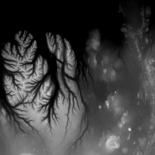
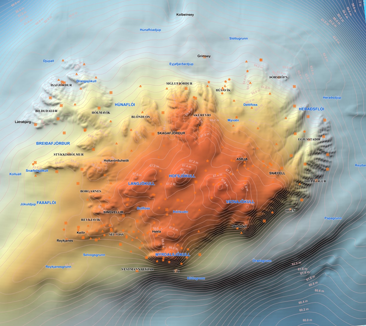
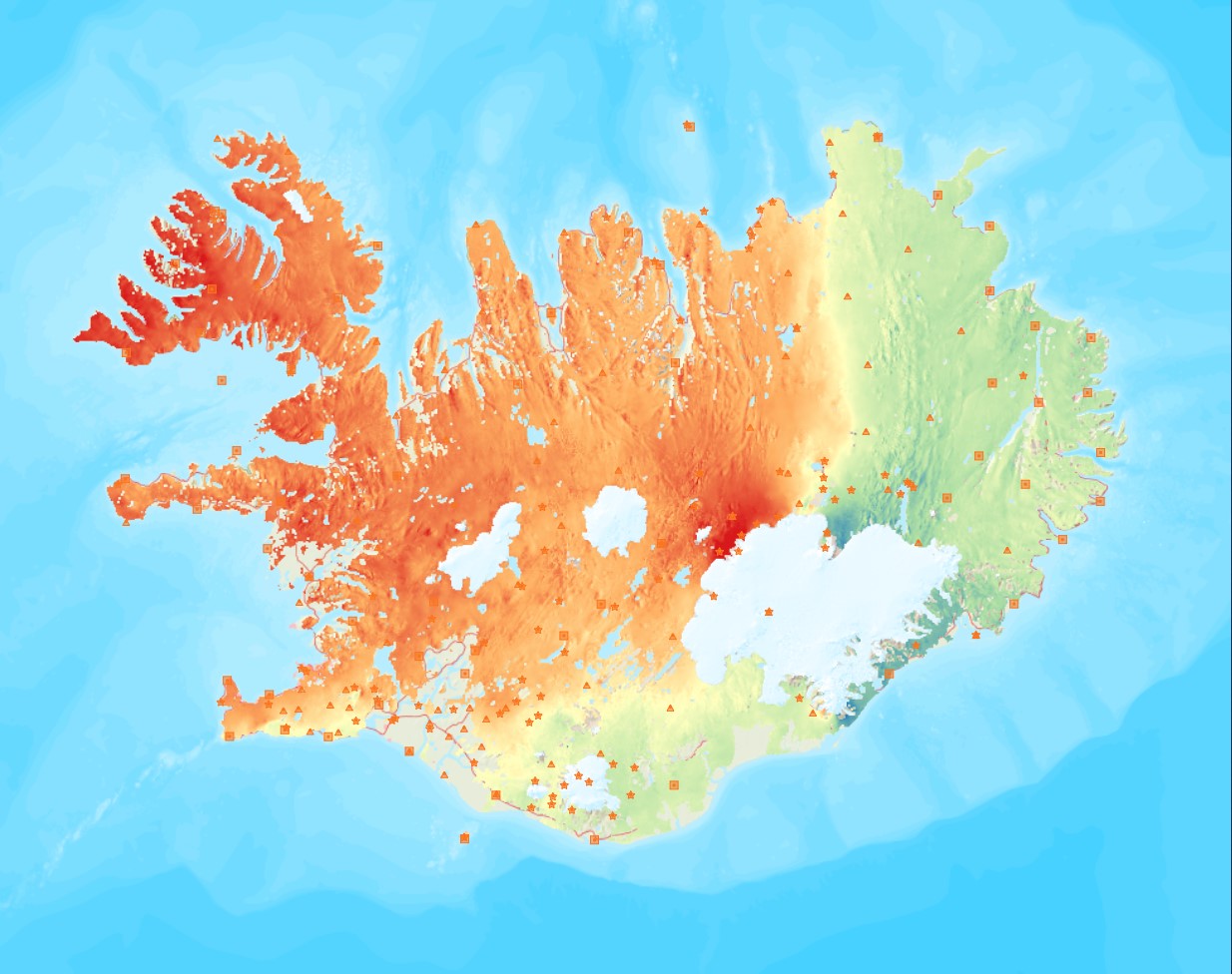
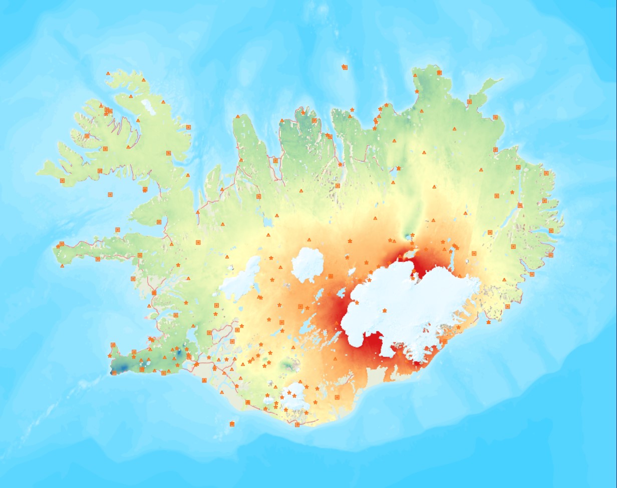
Landmælingar Íslands hafa unnið nýtt landhæðarlíkan af Íslandi. Um uppfærslu á eldra líkani er að ræða þar sem nýleg gögn af ólíkum uppruna þekja um 39.100 km2 eða um 38% landsins. Stærsta samfellda uppfærslan nær frá Suðurlandi til norðausturs, austur fyrir Egilsstaðir.Hæðarlíkanið hefur 10 x 10 m myndeiningar. Helsu nýleg gögn eru (sjá staðsetningu á meðfylgjandi smámynd hér fyrir neðan): 1) IPY-Lidargögn fyrir jökla landsins frá árunum 2007-2012, 15144 km2, LE90: 2,65 m. 2) Gögn úr 5-m-hæðarlínum, 10736 km2, LE90: 3,9 m. 3) Emisar radargögn, 4536 km2, LE90: 3,2 m. 4) Gögn úr 10-m-hæðarlínum, 2938 km2, LE90: 8,48 m, 5) SwedeSurvey photogrammetry gögn, 1433 km2, LE90: 2,60 m, 6) Gögn úr mælikvarða 1:25.000, 1152 km2, LE90: 3,8 m, 7) Bresk lidargögn (Dr. Susan Conway, Open University), 532 km2, LE90: 0,96-4,63 m. Líkaninu fylgir hæðarskygging, þ.e. upphleypt mynd af landinu en slíkar myndir eru gjarnan notaðar sem undirlag til að draga fram eða leggja áherslu á landslag. The National Land Survey of Iceland has made a new DTM of Iceland. The DTM is an upgrade of an earlier DTM where recent data, that vary in origin, cover 39.100 km2 or some 38% of the country. The DEM has pixel resolution of 10 x 10 m with. The main recent data are (see location on figure below): 1) IPY-lidar data for the glaciers of Iceland (surveyed in the years 2007 to 2012), 15144 km2, LE90: 2,65 m. 2) Data from 5-m-contour lines, 10736 km2, LE90: 3,9 m. 3) Emisar radar data, 4536 km2, LE90: 3,2 m. 4) Data from 10-m-contour lines, 2938 km2, LE90: 8,48 m, 5) SwedeSurvey photogrammetic data, 1433 km2, LE90: 2,60 m, 6) 1:25.000 contour data, 1152 km2, LE90: 3,8 m, 7) British lidar data (courtesy of Dr. Susan Conway, Open University), 532 km2, LE90: 0,96-4.63 m.The DTM is accompanied by a hillshade or a relief image of Iceland. Hillshade images are commonly used as a layer beneath maps or data to emphasize landscape.
-

Vatnajökull National Park was founded on June 7th 2008, although the act on Vatnajökull National Park was entered into force on May 1st 2007. It is the largest national park in Iceland by far, 14,967 km2. Vatnajökull National Park was inscribed as a UNESCO World Heritage Site on July 5th 2019. The boundary of Vatnajökull National Park, after its latest expansion on September 22nd 2021. The boundary is drawn in accordance to regulation on Vatnajökull National Park, No 300/2020, with later amendments. Disclaimer: If there is a difference between the data and the regulation text, then the regulation text applies. The data also includes all previous boundaries of the national park as well as current boundaries of operating areas.
-

Gögnin sýna hvar bráðamóttökur, læknavaktir og heilsugæslustöðvar eru staðsettar á landinu. Um er að ræða samstarfsverkefni Embættis landlæknis og heilsugæslunnar á höfuðborgarsvæðinu.